NOTE: IN ORDER TO BETTER SEE PHOTOS IN THEIR FULL 1600 PX. RESOLUTION, VIEW THEM IN THE ALBUM FORMAT BY CLICKING ON THE LEAD PHOTO OR ANY PHOTO IN THE POST. This is especially true for landscape shots. Thanks to Mark for the idea of adding this alert so the photos can be seen at their best!

Sunday, May 31, 2015

Roadside Rockets

My stay in Baraboo at Devil's Lake State Park ended up only being for Thursday night.  I paid for two nights and the first night was quiet but it's a busy park on summer weekends and apparently I ended up in the "young people" loop.  Too much noise for my taste so I packed up my tent and drove the two hours home at dusk.  I was pretty happy to be so close to home and able to make a decision like that, and now I know it's wiser to avoid the more popular parks in the summer.  It was much nicer in the spring when I camped under the rookery in the group camp area!

Ice Age Campground, 400 loop

They've been gradually replacing the shower facilities at Devil's Lake in their 3 campgrounds, but the Ice Age campground still has an older building whose pipes clanked alarmingly when I flushed the toilet.  There is also only 3 very small shower stalls with no benches and just 3 hooks for your stuff.  The shower stall is so small that the hook on the back of the door is useless unless you want to wear wet clothes afterward!  I didn't check out any of the new ones but they were working on them when I was here back at the beginning of April.  Entrance into the state park is only through the main gate and once you're in it's almost all one way roads laid out in a confusing manner, but it is well signed so just pay attention!  Both of my visits here I was disappointed to find the park staff kind of unfriendly and not very helpful when I asked questions, not common at all in our parks normally so I'm wondering what kind of crap they have to put up with from visitors to make them so surly.


I only stayed one night at the park, but I did hike for two days while in the area.  If you're seeing lots of tall purple and white (and sometimes pink) flowers blooming on the roadsides and at the edges of woods it's probably not phlox but Dames Rocket.  Phlox all have 5 petaled flowers where Dame's Rocket has 4 petals.  I saw so much of it Lodi when I drove there from the campground and was delighted because it reminds me of our days out on our farm.

roadside rockets

 As part of the drive from Devil's Lake to Lodi I decided to skip driving around the end of the Wisconsin River and took the free Merrimac ferry instead.  Yes, I said free!  Trip time is about 7 minutes, and I just missed the one that was leaving so it was probably 15 minutes before I got across.  Which just happens to be the amount of time "saved" by taking the ferry instead of driving around.  Still, it was a fun experience and if I'm driving by and the timing is right I'd take it again.  It does run 24 hours a day so you don't even have to worry about that.


My destination for this hike was the Groves-Pertzborn segment of the Ice Age Trail.  It travels up a steep hill with lots of wildflowers under the canopy including Wood Anemone, Wild Geranium, Solomon's Seal, Jack-in-the-Pulpit and Mayapples so large they came up as high as my hip!

Wild Geranium lined the trail

The Dame's Rocket was plentiful at the trailhead and some were even multi-colored.


Something else that was plentiful was Poision Ivy along a grassy stretch, so make sure you wear long pants and don't wander off the trail.

posion ivy alley

After 15 minutes of continual uphill hiking I came out into a ravine that took my breath away.  I felt like I was in a secret place and the world felt very far away.


After leaving the ravine it was a gradual downhill slope that cut right through a field of more Dame's Rocket.  Brushing against the plants released a light fragrance that is much less overpowering than the lilac in bloom now.

the familiar yellow IAT blaze 

Due to the dense vegetation I kept checking my boots for ticks eagerly crawling their way toward me, but surprising all I found trying to hitchhike a ride was a caterpillar.  These little green guys were everywhere, I picked them off my arms and clothes continuously.


Notice how soaked my Keens were?  They are supposed to be waterproof and I noticed them leaking when I wore them recently on the Point Beach segment too.  I'll be contacting them for a replacement which we had to do recently for a pair of Wayne's boots as well so I know I won't have any trouble getting the issue resolved.

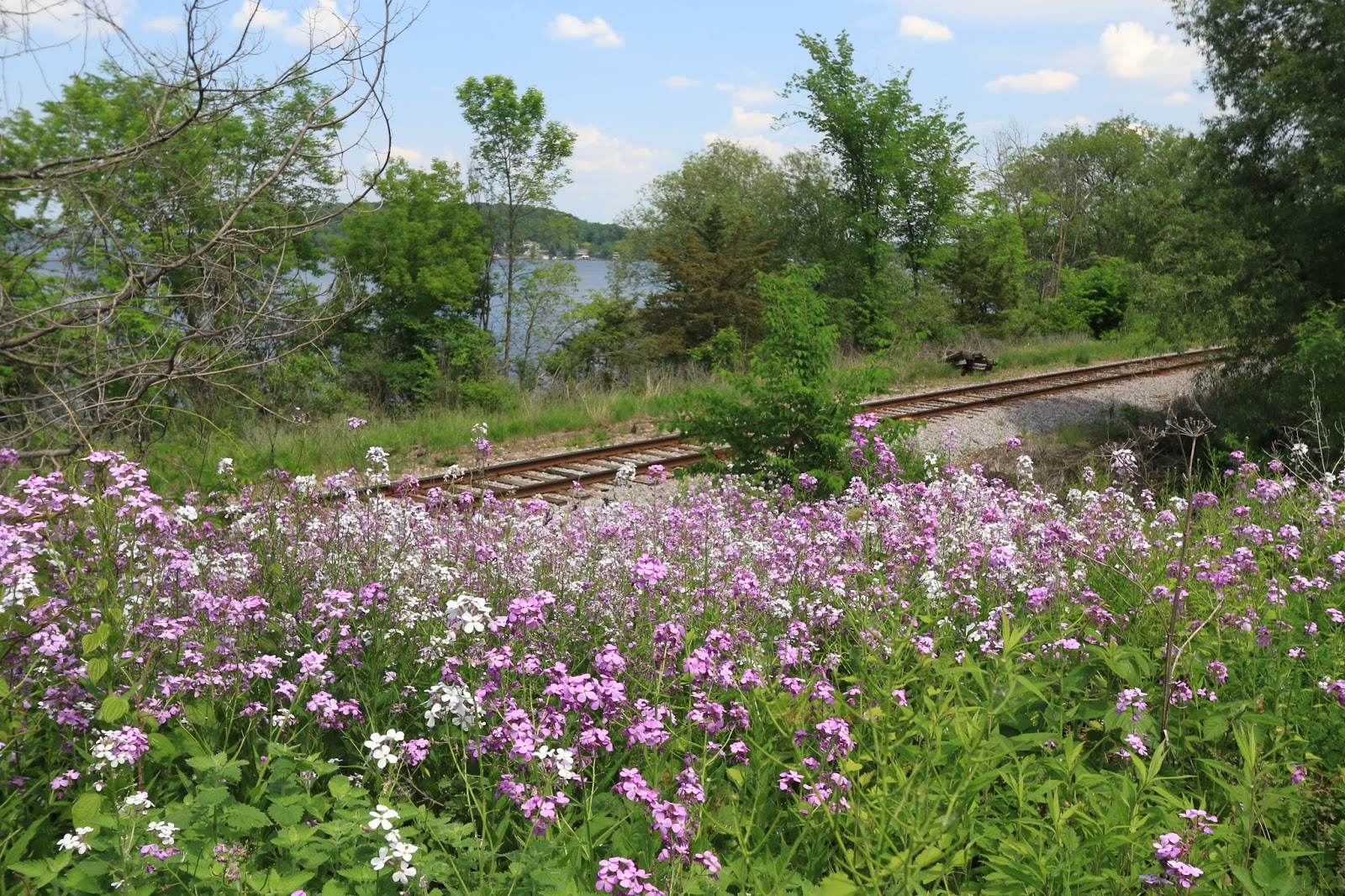
Dame's Rocket and the Wisconsin River

I took another hike while in Lodi, attempting the City of Lodi segment.  That turned in to an adventure I won't soon forget.  While I like an uneventful, relaxing hike the lack of stories to go with my posts has been a bit disappointing.  After I share this one with you I'll be okay without a story to tell for a while!

Friday, May 29, 2015

The Last of the North Shore

Well, last week we wandered from Duluth to Tettegouche and had a lovely time.

View from Silver Creek Cliff

The road used to go right up to the cliff edge there, some boulders on the side the only thing separating the motorist from experiencing their car sinking to the bottom of the lake.  Of course they drove a lot slower then and there were a lot less cars on the road, not to mention none of them were texting while driving!


Wayne, Cory and I went to Gooseberry Falls State Park and walked the Falls Loop, seeing the upper, middle and lower falls.  It was the weekend, so unlike when I went with my mother the place was packed with families out enjoying the sunny day and playing in the cool water.  We were hot and cranky, following the masses in a circle, feeling like we were on nature's conveyer belt.


We got our solitude when we stopped at Split Rock and found that secret entrance to the beach via the Gitchi-Gami State Trail.


While taking our adventurous shortcut I spotted one lonely Nodding Trillium.


Another spot we wanted to go back and explore was the the Beaver River in Beaver Bay.  They are constructing a new parking area right next to it and we were itching to go back and explore but ran out of time.

Beaver River 

Our last morning there the fog was thick and the Bluebells were dripping.


I'd been watching the emerging Bunchberry all week and they were just starting to open up, I hope I'll be somewhere soon to see them in their glory.  They were so gorgeous in Door County last year.


After spending a day at home cleaning and doing laundry I hit the road again and I'm camping up at Devil's Lake State Park for a few nights.  I can't believe how much overtime Wayne is working this year, sometimes I forget what he looks like!  Wait until you hear what I went through today while hiking the IAT in Lodi....

Thursday, May 28, 2015

Tettegouche State Park and a Brave Gull

The farthest we ventured along the North Shore in Minnesota was to Tettegouche State Park.

view of the Palisades from Shovel Point

One thing we noticed was that the signs along the road did not say "visitors center" but said "rest area" instead.   Luckily I convinced Wayne that it was where we wanted to go, but the confusion continued after I went inside to ask about trails.  Just like at Gooseberry Falls the map was fairly useless and once you leave the building there aren't any signs pointing you to the trailhead that is accessed from behind the building.  


It's weird because their facilities and the boardwalk system are top notch and look fairly new. 


There were great views from Shovel Point  but the lady in the VC didn't tell me that was all there was in that direction or I might've have skipped it.  We got our exercise anyway.


Back at the rear of the VC we went the other way and headed down to the beach, much more fun than another view of Lake Superior.


The strawberries are blooming everywhere in the area, even on the cracks of the beach boulders!


We must have tired Cory out because he wasn't very excited about climbing around on the rocks by the water like he usually is. 


I liked Shovel Point better from afar.  There was a good variety of lichens on the big rocks too.  


I didn't stop at losing my hat.  While jumping around on the rocks I dropped a polarizer and plunk! Just another donation to the universe.  Luckily it was an old one from the broken lens (that went plunk too, remember?) and it fell because I was just holding it in front of my 40mm lens.


After our exercise we went out to lunch at Northern Lights Restaurant and the food was pretty god, even the gulls eat there!


He gulped down a whole breadstick on one motion to the delight of the patrons.  Dinner and a show!  

There are more trails inland at Tettegouche. Maybe someday I'll have time to check them out and perhaps by then they'll have improved their maps and signs!

Wednesday, May 27, 2015

Split Rock Lighthouse

We didn't want to pay the exorbitant prices they were charging to get in to the Split Rock Historic Lighthouse, or pay for a Minnesota State Park sticker just to have a quick look at it either.  I knew there had to be a way around the situation, and when I checked Google maps I noticed the Gitchi-Gami State Bike Trail ran right in to the park.


Sure enough, there was a place to park less than half a mile from the park entrance and we walked right in to the park on the bike trail.  Being too adventurous for sticking to the paved path we cut down the embankment and Wayne picked up two ticks for his trouble, but luckily he saw them before they embedded.

Wayne schooled Cory in the fine art of going sideways down a hillside

Within 15 minutes we were down on the shore, getting a fine late afternoon view.  Unfortunately all I had with me was my 10-22mm lens so everything looks farther away than it really was.


I kept going on the beach, leaving Wayne and Cory behind in an effort to get close enough to see the lighthouse in my shot.


I knew I'd just have to come back on Tuesday morning bright and early with my zoom lens to try to get some better shots.  So I picked up my mom at 5:30 a.m. and we were back down on the beach by 6:15.  While I was too late for first light, I was right on time for some wispy fog that was just as photogenic.


That was the first shot out of the camera as I rounded the corner, can you believe it?  No editing in any of these shots, I was quite happy with what I got for how little preparation went in to getting there and getting them.  Could I have gotten better ones by bracketing and using Photoshop?  Absolutely, but someone would have to show me how first! (hee hee)  One of these days I'll get ambitious enough to learn.


After I walked away I turned back and the sun was trying to break through the clouds.  It was really too bright for color photography, but changing it to black and white produced a striking image.


I just loved the color of the lighthouse, so different from the white or red that you usually see.
From the Split Rock Lighthouse website: Completed by the U.S. Lighthouse Service in 1910, Split Rock Light Station soon became one of Minnesota's best known landmarks. Restored to its 1920s appearance, the light station offers a glimpse of lighthouse life in this remote and spectacular setting.


The little island where we accessed the shore was fun to contemplate too.  I bet folks paddle out to it and try to get up there.


More to come from our trip here on the blog, but we made it home yesterday after a long drive across Wisconsin from the northwesternmost point to the southeastern corner.  Let the rounds of laundry begin!

Tuesday, May 26, 2015

More to do in Two Harbors Than Hike


The little town of Two Harbors in Minnesota was settled in 1856 but didn't really get going until the railroad got up here to get the iron ore out of the area in 1884.


 By 1885 roughly 225,000 tons of ore were moving through Agate Bay prompting the Vessel Owners Association and the US Lighthouse Service to recognize the need for a navigational aid at Agate Bay. On August 4th 1886 the US Congress authorized $10,000 to build a light station.

My mom walking by the breakwater light

We didn't tour the lighthouse, I was content to see it from shore.  From the Lake County Historical website: The light was first lit April 15 1892, a continuous white beacon in all directions.  In order to help distinguish it from other lights on shore the original Fresnel lens is replaced with a four bulls eye lens and clockworks (rotating mechanism) creating a signature flash. As more electric lighting appeared on shore red screens were placed in the gallery to further distinguish the light signal.


Of course I got some shots of nearby Split Rock Lighthouse as well...but they were so inspiring that they deserve their own post!

While the bedrock of the area is interesting, I liked the Nonesuch Shale that we found along Lake Superior in the Porcupine Mountains region a little better.  The rock in Two Harbors made for interesting textures in photographs but was bumpy and awkward to walk on!

No starfish in Lake Superior!

Not far from the lighthouse by the ore docks is the Edna G tugboat.  She's pretty big as tugboats go, and painted a vibrant red and yellow that was nice to shoot in the early morning light when my mom and I went down there.


Also in the same lakeshore area is a couple of old engines and a Depot Museum.  I didn't get to the museum, but Cory and I walked down to see the engines when Wayne went in to True Value to get some screws to fix our sliding closet doors.


One night Wayne and I walked toward town along the shore from the campground.  There was a paved path through a Veterans Memorial Forest along the shore and we got a nice view of the campground to go with our exercise.


A week is enough for the area for most folks unless you're planning to hike the Superior Hiking Trail, but there is lots to see in the 30 miles from Two Harbors to Split Rock State Park if you like the outdoors. I didn't get to hike the Split Rock River Loop that John and Pam recommended because the rain came in on our last full day, so if I'm ever up here again I know where I'm going to start!

We also had a fantastic dinner at Black Woods Grill in Two Harbors.  We don't eat out often because we're invariably disappointed, but everyone's food was well prepared and the waitress was patient with all our questions.  My mom and I had lunch one day at the Vanilla Bean too, and that was good as well though their menu is limited.  Of course the best find was the Great Lakes Candy shop on the scenic highway in Knife River.  I came away with a variety of chocolate but my favorite was the dark chocolate bar with almonds and toffee - Yum!

Monday, May 25, 2015

Washburn Iron Works Mural

When Wayne and I visited the Bayfield area last year we saw this mural in Washburn portraying the Washburn Iron Works.


Monday Mural in Two Harbors

Two Harbors is a very small town but they did have at least one mural!


It features what I assume is the Edna G. tugboat, a steam engine tugboat built in 1896 and still operational.  She "retired" in 1981 after serving the area for 84 years.  They do tours of the tug according to a sign I saw, but I don't know if they've started for the season yet.


I've got pictures of the Edna G. as well as some other Two Harbors attractions coming up tomorrow.  Linking to Monday Mural.

Saturday, May 23, 2015

Going the Wrong Way and Losing my Hat


With Wayne off on a mission to find a boat and go fishing with my dad and Cory, I decided I'd tackle a section of the Superior Hiking Trail.  Detailed information about the trail is hard to find on the internet (is no one in Minnesota blogging about their hikes?) but there is a store in Two Harbors with merchandise and information about the trail.  None of the information is free and my mother made the mistake of writing on what she thought was a free pamphlet and the gent behind her bought her $1 mistake for her since she hadn't brought her purse.

Loaded up with camera gear and raring to go!

Armed with our $1 map (no more information than a line on a piece of paper, really) we headed to the road where the trailhead was located for the section that I wanted to hike.  I planned to go 9 miles from Castle Danger to Gooseberry Falls and have my mother pick me up later.

lots of lichen on the trail

I was so excited that I didn't really give the sign I posed at more than a glance.  All I did really notice was that it didn't say Gooseberry Falls but I thought maybe it was because there would be a sign farther along with additional destinations.  There was also a sign hanging across the trail entrance warning of a water crossing ahead with details on how to go around via the road for thru hikers that didn't want to get wet but I had on my waterproof Lowa boots so I was all for it.

Sudden drop-off at the top, better pay attention!

The first half mile was a narrow track through the muck and trees but I wanted to go slow and not miss anything.  Good thing I was going slow because the trail stopped at a sudden drop-off and a stairway was built in to the side of the rocky ravine after navigating a few outcrops of rocky "stairs".


At the bottom was a bridge crossing Crow Creek and the view down the ravine was pretty cool.  I didn't even mind the slope I had to climb on the other side.  I thought it looked like a fun adventure and assumed that most of the rest of the hike would be not as steep.

loose rock, step carefully!

From there it was a continuous roller coaster of gradual uphill swings until I was at the top and looking out over Lake Superior from what I assume is Red Pine Overlook.  I of course would know none of this if not for the sign I thoughtlessly posed in front of.  It was the only sign on the 5.3 mile trail section besides the blazes.


Again the day was relentlessly sunny and I took off my hat and draped it around my neck to let the heat out from my head for awhile.  By the time I got to the lookout it was gone, dropped along the way.  I thought about going back a ways to look for it and decided it was my least favorite hat anyway and I was going too slow as it was.


I thought for sure now that I was "at the top" the going would get easier and I could pick up the pace but the trail was barely a trail and with every step I was picking over rocks and roots and other obstacles which slowed me down quite a bit.  I stopped for a rest even though I felt the clock ticking.  I even got to watch some little blue butterflies swirling around.  Similar to the Karner Blue, but without any orange spots and not as vibrantly blue.  I don't know what they were, but they were so tiny that those "sticks" in the picture are dried pine needles.


Eventually what goes up must come down and it was time to cross Encampment River.  I checked my phone for the picture at the trailhead and was dismayed to realize I had still only gone 2.6 miles.  They were hard miles!  No way was I going to be able to do 9 miles that day unless the terrain got much easier.

Encampment River

I only got wet up to my ankles, thanks to my hiking stick

Safely across the river I wearily eyed the trail as it ascended yet another steep climb.  Up, and up, and up I went, getting so hot and exhausted that halfway up I had to stop in the shade and remove my shirt to let myself cool down for a few minutes.  No worries, the woods were so quiet that I doubt even a squirrel saw me and got shocked to see a lady lounging around in her sports bra.


More views and a short stretch where the walking was a little easier.  By this point I was checking Google Maps and confused as to why it was showing I was south of my departure point instead of north of it.


It took me awhile to figure it out, but there must have been two different trailheads within the parking lot, one going north and one going south.  How did we miss the other one?  The trail had started out in the right direction but then taken a sharp turn according to the map and then recrossed the road the lot was on a little further up.  I only crossed 3 roads and none of them were marked like they are on the Ice Age Trail.  Something I took for granted in Wisconsin could have saved me a lot of trouble here in Minnesota.  If there had been a sign stating the name of the road I would have known quite a bit sooner that I was going the wrong way.

First time I've seen Morels in the wild!

Slightly embarrassed that  I'd been laboring in the wrong direction, the fun was definitely gone out of the hike that I'd been struggling to enjoy as it was.  Between the picture from the trailhead on my phone and Google Maps I figured I had roughly another 2 miles to go before I could get out to a road and have my mother pick me up. Rough turned out to be an apt word, first there were more ups and downs to tackle.

More like rock climbing than a hike in some spots!

Left knee throbbing, back sweaty, I finally made it to Route 613 and called my mom to come get me.  I  walked another 0.8 miles on the lovely and flat downhill dirt road.  Who knew I'd ever be so happy to see a dirt road?  Seems like I'm always learning lessons on these hikes.  Stow away your hat more securely, make sure you don't leave your hiking stick leaning against a tree, and oh yeah, read the signs and make sure you're heading in the right direction!