From there I drove over to Neshotah Road to get on the IAT. I scoped it out last night, and it's a good thing because the sign for Park Road is hidden in vegetation. Using my GPS would have been a better idea than driving up and down Neshotah looking for the turn. I've been keeping track of some of the GPS coordinates of the trailheads when I remember to get them and at some point I'll do a separate post that includes all of them. The Point Beach segment starts here.
Once you find the trailhead in the cul-de-sac it's a short 3 minute walk through the woods and then you emerge onto a cordwalk on the beach. This morning it was cold and foggy, but I could hear a distant foghorn and I had the "beach" all to myself.
Of course that means I had somewhere good to lay down and get a shot from ground level.
 |
| Lyre Leaved Rock Cress is in bloom |
I easily spent my first fifteen minutes going nowhere as I fooled around with my camera, taking advantage of the morning's dampness to get some fun shots.
 |
| Sand Dune Willow salix cordata |
 |
| Bearberry blossoms down in the sand |
"The Ice Age Trail Guidebook" will tell you to head north along the beach for two miles, something I should have paid more attention to before I headed out. The part I remembered was about the trail marker being easy to miss and to pay attention because if they went too far they would have to ford some water.
So I followed the beach, keeping my eyes peeled, sure I would miss the marker as sand does not make the best place to put trail signs. I realized later that in the future it might be helpful to take a picture of the guidebook page as well as the GPS,
After probably less than half a mile I came to what looked like a pond, and the water continued on its way north, a deep swale that looked like it just got bigger and harder to cross. Certain this meant I had missed the trail marker I backtracked a little and crossed the swale.
Back up on a dune ridge I looked north and south. Figuring it would be better to go back south than continue on in the wrong direction I turned back the way I had come.
 |
| most likely Starry False Solomon's Seal sprouting on the dunes |
 |
| wandering the dunes in search of the trailhead |
I found a well used footpath that went in to the woods, and stuck with it even though there were no yellow blazes. I knew there were a lot of paths through the area and most intersected so figured that I would just turn north again at some point.
 |
| crossing a swale |
Well, it turned out I just ended up out on the main road. Checking my Google Maps app (something I could've done on the beach if I had been smart!) I determined that I had 2 miles to go before the next entry point to get to the IAT. Thinking of slogging through the sand or walking on the gravel shoulder....I chose the shoulder. I had just passed through the woods in habitat that likely mirrored what I would find further on along the trail and decided the experience was the same, the miles were the same, why go back just to say I had logged every tenth of a mile of the official trail.
 |
| Is that a torpedo? |
On Sandy Bay Road there were things to see that I would not have seen in the woods. Folks around here love to dress up their driveways and mailboxes, keep your eyes open because who knows what you'll see.
 |
| Skull of small animal caps the birdhouse on the right |
 |
| Done with your pitchfork? Make it an ornament! |
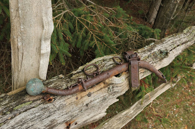
There was even something I didn't recognize attached to some fence rails. What the heck? The rings made me think of the thing they used to attach to oxen who were plowing a field, but I'm probably way off.
My favorite was probably the Greek looking head sitting on a stump under a windmill. A large metal bird seemed ready to reach down and have a peck at it.
Some birds and squirrels provided entertainment. When the whole day stretches out in front of you with nothing but trail miles to fill it you can waste all kinds of time.
 |
| See the Bluejay in the upper left corner? |
A little further along I saw some really special critters, but I'll save that for Part 2. The Verizon signal is awful everywhere in Two Rivers so I had to travel to Manitowoc to get wi-fi or even be able to text, but my toes are freezing here at Starbuck's and I have to save something for the next installment. What would you have done, gone back and looked for the trail or followed the easier route on the road? You know what I chose, so for now I'll be like Judy and just say THE END.


I would have done just what you did. Love the foggy pictures and the one of you walking into the fog.
ReplyDeleteYou are such a trooper! The fog would have kept me in:) Love the adorable flowers. Great photos:) I still can't believe you set off alone. I have NO sense of direction so I would never return:)
ReplyDeleteI would've chosen as you did. Slogging thru sand is not my idea of fun ... but seeing other folks' interesting "yard art" is.
ReplyDeleteHiking on the IAT looks COLD!