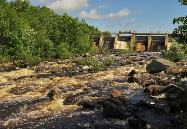
The Grandfather Falls segment is on the right side of the river pictured below. I'll try the other segment tomorrow.
I also found a complete overview map of the trail at the end of the hike. In case you are curious about why it is taking me so long to get anywhere on this trail this should help clear up the mystery. Wisconsin is big and the trail is curvy! The red dashes are proposed areas, solid red is existing trail but almost half of that is road miles that I refuse to hike. Blacktop? No thank you!
The little blue arrow in the bottom right corner is about where I live, and the red arrow near the center of the map is where I am now. As I mentioned it I drove about 240 miles to get here yesterday.
The trailhead for Grandfather Falls is easy to find, just pull in at the large sign right on the side of the highway. From the parking lot I heard the sirens go off signaling that the gates were open on the dam and to be careful of rising water levels on the river. The total drop is 89 feet spread out in a series of cascades over about one mile. The upper third of the falls and most of the flow, except in the spring, is diverted through a canal and a series of penstocks to feed hydroelectric generators.
I have to say it was the most interesting start to a hike on the Ice Age Trail that I've yet experienced! The trail itself started just to the left of where I stood below the dam.
The woods up here have seen much more rain than we have in the southern part of the state and things were lush and green, with fungi and lichen evident everywhere as well.
A little further along there was a spot to leave the trail and get a good look at the mighty Wisconsin River. I've got video at the end of the post so you'll get to hear that rushing water!
The beginning of the trail was quite rocky, both underfoot and in the form of big boulders on either side of me. It soon transitioned to a spongy forest floor where I switched from navigating rocks to trying not to get tangled up in roots. The trail is level, but definitely not flat so hiking boots for ankle support are still a good idea.
Soon enough I was making my way out of the woods and up to the canal and penstocks area. I found a great link on all the details of the dam and how everything works here, if you're interested in that kind of thing it was brief but informative.
The tubular penstocks that carry the diverted water down to the plant have sprung quite a few leaks. Not the best maintenance plan going on, but very fun to look at.
I had the choice to continue on at this point, turn around, or take the driveway by the canal out to Hwy 107 and walk the road back to my car. I chose the easier road hike and then drove down to Camp New Wood County Park to pick the trail up again. The mile and a half that I skipped in the middle of the segment was nothing special, and it turned out that the other mile and a half at the far end was overgrown and buggy so my advice is to just hike it as far as the red brick hydro building unless you're collecting every IAT mile which I am not. Roundtrip for that portion is just under two miles and was a very pleasant hike.
Here's the video, some nice stuff in that one mile!


We have distant reltives in Racine. Love that leaky pipe. There was one made of wood here that leaked like that, but it's been replaced by steel pipes and buried.
ReplyDeleteLove the frog in the first photo and the leaky pipe, bet you stood there waiting for it to bust
ReplyDeleteNice fungi and lichen
ReplyDeleteAnd here I thought they were all Frog Princes. My bandwidth didn't allow me to see and hear the video but I really enjoyed your pictures of all the lush green especially from here in New York where it hasn't rained in over a month and all the waterfalls I came to hike to are drying up. Beautiful green trail that looks like a rain forest. Love the RED mushrooms. They must be poisonous to be that striking.
ReplyDeleteI know about the rains in upper Wisconsin! If you saw my last post, you know about it, too. We couldn't get any hikes in, darn it. That raging river looks amazing!
ReplyDelete